Alternate Route to Range 10
Around the back way
Michigan Rifle & Pistol Association
Rifle Silhouette Division
Maps and Directions to Rifle Silhouette Ranges
Silhouette Home | Match Schedule | Match Results | Photo Gallery | Contacts | Maps | Articles | Rules | History | MRPA Home
Maps and Directions to Rifle Silhouette Ranges
Camp Grayling, MI
MRPA Silhouette Matches - Range 10
Alma, MI
Alan P. Goodrich Rifle and Pistol Club
Alpena, MI
Alpena Sportsman's Club
Dorr, MI
South Kent Sportsman's Club
Gaylord, MI
Northland Sportsmen's Club
Superior Game Ranch
Ypsilanti, MI
Washtenaw Sportsman's Club
MRPA Silhouette Matches - Range 10
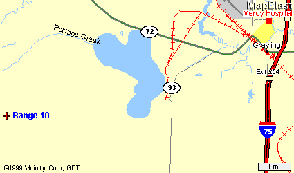
Camp Grayling Military Reservation is located west of Grayling, Michigan. Go west on M-72 from Grayling to M-93 and south on M-93 to the Military Reservation. Go past the guard house approximately five miles to Range 10 staying on the main road. The entrance to Camp Grayling is about where the number 93 is on the map below.
Click Picture for Full Size
Alternate Route to Range 10
Around the back way
Click
Picture for Full Size
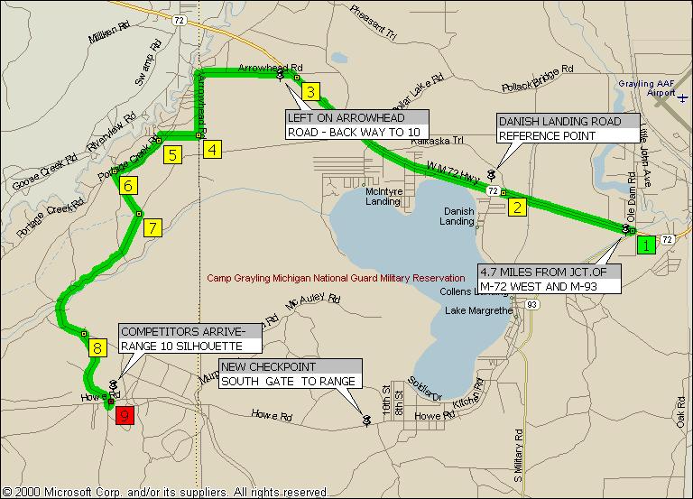
Directions to Camp Grayling - Range 10
Via: Arrowhead Road
1. Starting just West of
Grayling at the M72-M93 junction take M72 West 4.7 miles
2. Going past Danish Landing Road and Lake Margrethe to Arrowhead Road.
3. Turn left (West) on Arrowhead Road and go 1.1 miles until it curves left
(South) and turns into Kalkaska County Line Road. Continue South on Kalkaska
County Line Road .7 miles
4. Road makes a right turn and you are heading west for .4 miles
5. At the fork in the road go left (SW) onto Portage Creek Road and continue for
.5 miles.
6. At the next fork take the left fork (SE); this takes you into Camp Grayling.
7. Continue SE .3 miles and then turn right at the sign that directs you to
Range 18. Continue past the road to Range 18 through the s-curve to the right
and then back left a total of 2.1 miles until you come to the pavement at the
Portage Creek Bridge.
8. Continue on the pavement then turn left (East), at the big rock, onto Howe
Road. Go East .4 miles
9. Range 10 will be on the left (North) side of the road.
GPS Numbers for Range
10
N 44° 37.595
W 084° 51.929
Alma, MI
Alan P. Goodrich Rifle and Pistol Club
Take US27 to Polk Rd. exit; (first exit north of Ithaca)
Proceed, about one mile, east to first intersection (Croswell Rd.)
Turn Left (North) for one mile. Road dead ends at range gate
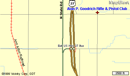
(AlmaMap.gif)
Alpena, MI
Alpena Sportsman's Club
Road to Club House and Range is on North side of M32 just east of the Airport
West From Alpena about four miles
Look for Sportsman's Drive Road Sign
Proceed north on Sportsman's Drive
Bear right at clubhouse and follow road to range
Click Picture for Full Size
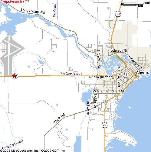
(AlpenaMap.jpg)
Dorr, MI
South Kent Sportsman's Club
Gaylord, MI
Northland Sportsmen's Club
Watson, MI
Superior Game Ranch
Ypsilanti, MI
Washtenaw Sportsman's Club
I-94 exit 181, West on Michigan Ave. [US 12]
Turn left (south) on Ellis Road immediately west of Gas Station on north side
Follow Ellis Road east (¼ mile) which turns south to range entrance (½ mile) on left (east)
Smallbore Silhouette Range is across from Club House
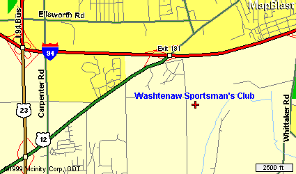
(WashtenawMap.gif)
Silhouette Home | Match Schedule | Match Results | Photo Gallery | Contacts | Maps | Articles | Rules | History | MRPA Home
Send email to
Webmaster with questions or comments about this web site.
Revised: 08/31/2006